A huge chunk of the UK is set to welcome an unexpected blanket of in days - just as Brits across the country were beginning to bask in a balmy spring temperatures. According to new maps by WXCharts, the shock cold snap is set to send temperatures plummeting, with possible lows of -1C in .
Intense flurries are expected fall across one region, while other major cities will welcome spells of rain. It comes after the warned of unsettled weather making a return towards the end of April before a shift back to warm weather at the start of May. According to WXCharts' data, Scotland will welcome snow on Thursday, April 24 - with Inverness, Aberdeen, and Wick among the areas in the firing line.
READ MORE:
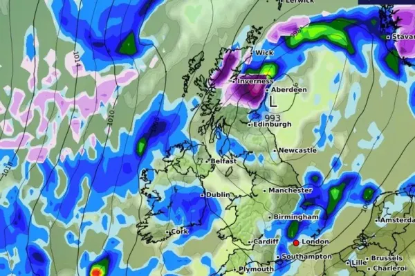
The late-April chill is also set to bring temperatures down in the region between -1C and 2C. The rest of the UK won't escape the unsettled weather, the forecaster predicts.
Birmingham, London, Plymouth, Southampton and parts of Greater are set for a soaking during the afternoon and early evening.
The Met Office said unsettled weather is likely to make a return towards the end of April before a shift back to warm weather during the first week of May.
In its long-rage forecast from Thursday, April 24 until Thursday, May 8, the agency said: "Some unsettled weather is possible at this start of this period with showers or longer spells of rain in places.
"However, a change to more settled conditions is most likely through this period as high pressure becomes more influential.
"This settled theme continues into early May, although some spells of wetter, unsettled weather remain possible, especially in the south. Temperatures are expected to be above average overall."
News of the upcoming snowfall comes just weeks after Brits were facing another hot day with temperatures expected to reach 20C this week - making the UK hotter than Rome.
The Weather team also warned "uncertainty remains" from Monday 14 to Sunday, April 20.
"Towards and beyond the middle of April, the long-range weather forecast models continue to differ," it added. "Some continue to show a persistent high pressure signal over the far north and north-west of Europe with an ongoing colder risk.
"In view of this, a mostly drier and calmer trend could prevail. Temperatures might be slightly above average but could still drop below average at times, bringing a slight risk of overnight frosts.
"A number of long-term forecast models are sticking with a stronger low-pressure signal in the eastern North Atlantic or close to the UK, which would point to above average temperatures.
"As a result, rather wet and windy conditions may return and possibly persist during this week."