As many as 40 counties across the UK could soon see heavy as an Arctic looks set to batter , and in just a few days' time.
The UK is currently in the midst of a balmy with temperatures rising as high as 23.7C for some of Friday - which was the hottest day of the year so far. However forecasters expect this warm spell to soon come to a rather chilly end, with Weather suggesting "air masses of Arctic origin" could bring "cooler or colder conditions" to the UK later this month.
READ MORE:
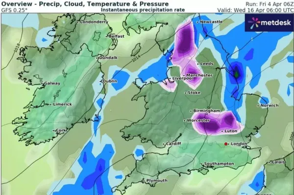
The GFS weather model shows snow moving across northern parts of England, southern parts of Scotland and Wales at around 6pm on April 15. Where flurries are most intense, the data suggests snow could be falling at a rate of around 1cm per hour.
By midnight on April 15, the heaviest snow is expected to be focused along the England-Wales border. As much as 3cm could be falling per hour in Shropshire around this time.
And the snow should continue falling into the early hours of April 16. The GFS weather maps show the Midlands, Bedfordshire, Cambridgeshire, the Pennines and the north-west of England could all see some serious snow at around 6am. Cities such as , and Luton all appear to be in line for a dusting.
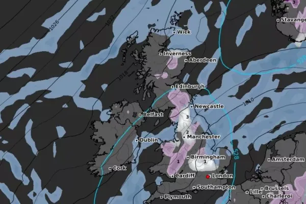
Snow coverage maps for 6am on April 16 reveal the full extent of this Arctic blast, with snow expected to settle on the ground from southern parts of Wales right up to northern parts of Scotland. The Pennines should see the most snow, with 3cm predicted to settle there.
The says that, although some "very warm" weather is on the cards this month, conditions are likely to "turn more unsettled" around the middle of April.
The Met Office forecast for April 9 to April 18 states: "High pressure expected to prevail early in this period maintaining largely settled conditions. This should result in largely dry weather with plenty of sunshine for most. Daytime temperatures will depend on the wind direction and cloud amounts, but most places will be warm for most of the period, and very warm days most likely will be further inland. Coasts with an onshore flow tending to be cooler.
"Overnight frosts are possible on clear nights where winds fall light. There is also the chance of some areas of low cloud or fog, notably around the east coast. Towards the middle of April, the weather is likely to turn more unsettled for a time with a greater chance of showers or longer spells of rain for all regions."
The BBC Weather forecast for April 14 to April 27 states: "Beyond the middle of April and towards the end of the month the long-range weather forecast models now show less agreement, meaning that some of them continue to show persistent high-pressure over the far north and north-west of Europe.
"In view of this a mostly drier and calmer trend could predominate, albeit with caveats. Temperatures might be close to the average values for this time of the year, but could also drop below average at times, including still a slight risk of late overnight frosts.
"Regarding the caveats, an increasing number of long-term weather models show a stronger low pressure signal near Greenland, which would imply a more active North Atlantic flow pattern setting in at some point of this forecast period or even earlier, along with temperatures rising above average. Rather wet and windy conditions may return at least to the north-western half of the UK then."