Don't pack your fans away just yet - at least not if you're a Southerner, as the latest charts show a stark North-South divide in the weather this weekend.
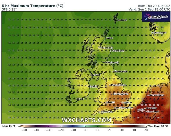
New weather maps reveal that summer isn't quite over with temperatures spiking to 26C in the south of England this weekend.
Meanhwile one weather expert has told Brits to "savour it while you can" and predicts September could very well be sunny.
The warmest of the weather on Sunday, September 1 is around the London area, with a predicted top temperature of 26C.
However, much of the south is set to be warm - with the heat of around 25C spreading out to as far north as Birmingham and west to Cardiff with the mercury set to reach 24C there.
In the north it's a cooler picture - with the chilliest of conditions to be 12C in the Scottish Highlands. Newcastle can expect a high of 17C.
Senior meteorologist and founder at British Weather Services Jim Dale said that summer could very well extend into September.
He said: "It's correct, a new month and autumn dawns with a predicted 27C in south east England.
"Savour it if you can. Though it may not be the end of summer-like weather just yet, September can deliver in spades!"
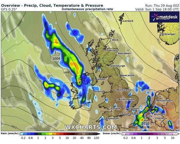
Meanwhile, however, The Met Office is more cautious about predicting a balmy weekend.
Its outlook for the weekend says that it's "mostly fine and dry on Saturday across the UK" but added that it predicts it will be "cloudier on Sunday with a risk of some rain reaching the far northwest and some thunderstorms across the south."
The Met Office also issues a longer range forecast which covers from Tuesday, September 3 until Thursday, September 12.
It said: "High pressure is most likely to be located either over or close to the UK through much of this period, leading to a more widely settled period of weather for most, with some cool nights, but near or slightly above average temperatures by day.
"That said early in the period a weak showery regime may still be clearing east. Later weak frontal systems could provide some cloud and patchy rain in north-western areas at times.
"There is a chance of some heavy thundery showers and more humid conditions in the south too, particularly later in the period when the high pressure may begin to drift slowly to the west.
"However, many areas are more likely to be drier than normal with predominately settled weather and light winds."
Contact to : xlf550402@gmail.com
Copyright © boyuanhulian 2020 - 2023. All Right Reserved.