Newly-released maps reveal the exact date England, Scotland and Wales will be hit with 3cm of per hour.
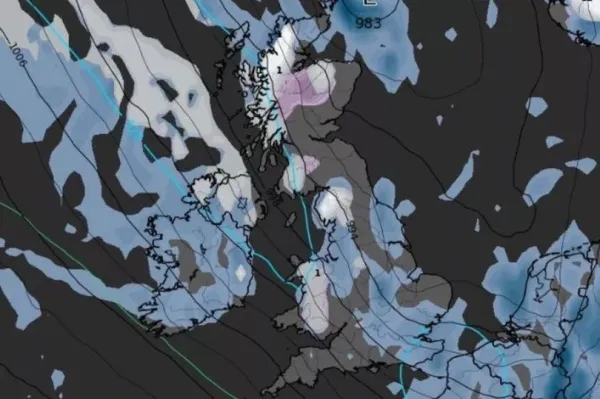
According to WXCharts, temperatures are set to improve slightly in the coming days, before taking a turn for the worse once again later this month. The latest maps suggest that several parts of the UK, including areas of , Wales and England, will see snow from 6am on March 26.
The will see most of the snow, with an average of 3cm per hour on the cards. Parts of Wales, including Swansea and Cardiff, are also set to be blanketed.
READ MORE:
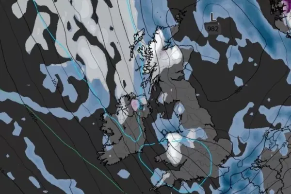
Later in the day, snow is also expected to develop in northern England, mainly in the Greater area, the reports. Although many areas will escape the snow, showers will also hit many parts of the nation, especially further down south, such as London, Canterbury and Brighton.
The has warned Brits that they should expect some unsettled conditions towards the end of the month. The long-range forecast from Wednesday, March 14 to Friday, March 28 reads: "High pressure is expected to be centred to the east of the UK initially, with a good deal of fine, dry and reasonably sunny weather in a south to southeasterly flow. Temperatures are expected to rise, to well above average in some areas.
"Later in the week there will likely be a gradual transition to less settled conditions from west to east, as low pressure becomes more dominant with an increasing chance of rain or showers by the weekend and into the final week of March, perhaps heavy in places. Temperatures, initially above average, will likely trend back closer to normal, although with more cloud this will tend to reduce the risk of frost to an extent."
At the beginning of April, there could be a mixture of dry conditions and wet weather in the form of rain or showers, the Met Office said. According to the long-range forecast from Saturday, March 29 to Saturday, April 12 says: "Confidence is naturally rather low, but blocked patterns are generally more favoured for the end of March and first part of April.

"This can lead to slow-moving areas of low and high pressure, and depending on their location can result in extended periods of either dry conditions or, perhaps more likely, wetter episodes in the form of rain or showers. Either way, whilst temperatures overall may be near average, given the time of year this type of regime tends to increase the chance of periods of below average temperatures at times."
UK 5 day weather forecast This Evening and Tonight:Some showers will continue to affect easternmost areas tonight. Elsewhere it will become generally dry with clear periods. A widespread frost with a few fog patches, and the odd icy patch too. Breezy in the far north and far south.
Saturday:Frost and fog clearing to leave a lot of fine , though cloud bubbling up to produce one or two showers. Patchy rain in the far north. Mostly light winds.
Outlook for Sunday to Tuesday:Mostly dry, though fairly cloudy on Sunday. Becoming breezy on Monday and Tuesday. A few showers in the southwest, but increasing amounts of sunshine elsewhere, and slowly turning milder.